 Everything to run

⚙ Voice settings
WILLCOX, Arizona — October 21, 2026. The United States has a new national park on the map — although the protected landscape itself is more than a century old. President Donald Trump signed the Chiricahua National Park Act on October 20, 2026, formally redesignating Chiricahua National Monument as Chiricahua National Park. It becomes the country’s 64th national park and Arizona’s fourth.
The National Park Service confirmed the redesignation in its October 20 announcement. Chiricahua, located near Willcox in southeastern Arizona, is famous for forested “sky islands,” towering rock spires, balanced boulders and the cultural history of the Chiricahua Apache. The new designation is likely to draw greater interest from international travelers and Californians planning road trips across the Southwest.
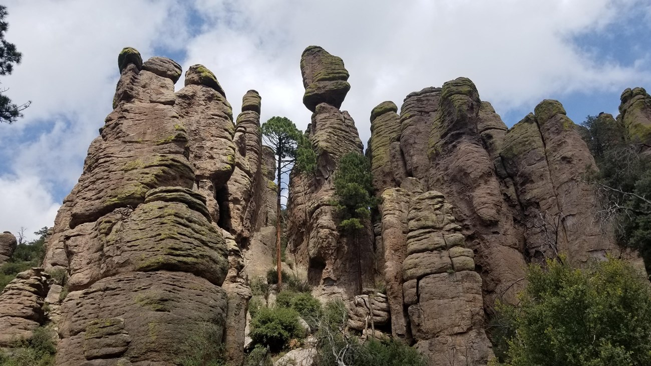
Cover photo: U.S. National Park Service, Echo Canyon trail area, from the NPS visitor guide. The landscape photograph predates the redesignation; it does not show the signing ceremony.
What makes Chiricahua so unusual?
The national park protects approximately 12,000 acres of volcanic landscape. An eruption about 27 million years ago formed deposits of rhyolite and related rock, later shaped by erosion into extraordinary pinnacles and natural columns. The park’s rugged elevation creates a mosaic of desert, grassland and woodland environments, making it an important place for birdwatching, wildlife observation and stargazing.
Its cultural history is equally important. The lands belong to the ancestral homeland of the Chiricahua Apache, whose history goes far beyond the federal national monument designation established in 1924. The NPS also preserves the story of early homesteading families at Faraway Ranch. Responsible tourism should recognize both the landscape and the people connected with it.
Is admission free in 2026?
According to the currently published official NPS fees page, there is no entrance or parking fee at Chiricahua. You do not need to buy an America the Beautiful annual pass just to drive into this park. The fees page may still use the former “National Monument” name while the park updates its materials following the October 20 law.
Do not confuse free park entry with free camping: Bonita Canyon Campground has its own nightly rate and reservation requirements. Because the new national park status may lead to administrative updates, check the NPS website again before traveling.
How to get there from California
The most practical way to explore Chiricahua is by car. From Los Angeles, drivers can generally use the Interstate 10 corridor across Arizona toward Tucson and Willcox. From San Diego, another option uses the Interstate 8 and Interstate 10 corridors. Travelers from San Francisco or Northern California may prefer to compare flights to Tucson or Phoenix, then rent a car.
The nearest major airport recommended by NPS is Tucson International Airport (TUS). Phoenix Sky Harbor International Airport (PHX) is another option, but driving farther may outweigh a cheaper airfare. The best itinerary depends on dates, budget, hotel location and whether you also plan to explore Tucson or other Arizona parks.
From Willcox, follow Arizona Highway 186 and then Arizona Highway 181 to the park entrance. NPS warns that the park has a single main road approach and limited cellphone service. Download offline maps in advance. Some roads and parking areas have restrictions for large RVs, trailers and long vehicles.
Read official directions and vehicle restrictions from NPS.
Four things to see
1. Massai Point
A scenic drive climbs into the rocky landscape and finishes near Massai Point. It offers panoramic views of the park’s volcanic pinnacles without requiring a full-day hike. Check parking and access conditions before driving uphill.
2. Echo Canyon Loop
The classic Echo Canyon Loop combines several trails and takes hikers through passages between spectacular natural stone columns. The approximately 3.3-mile loop generally requires several hours, appropriate footwear and enough drinking water. See the official NPS Echo Canyon route information.
3. Heart of Rocks
This is a more demanding destination for prepared hikers, known for balanced rocks and unusual formations. It involves a considerably longer walk than a quick roadside stop, so allow sufficient daylight and verify trail conditions. It is not a suitable substitute for a short accessible viewpoint.
4. Bonita Canyon and Faraway Ranch
Shorter walks, birdwatching and the park’s historical areas give visitors who do not want a strenuous trek a different way to experience Chiricahua. Check the current accessibility guidance and the visitor center’s operating hours.
Where should you stay?
Willcox is a useful starting point for groceries, fuel and lodging searches, while Tucson offers a larger selection of hotels, restaurants and transportation choices farther from the park. Inside Chiricahua, Bonita Canyon Campground has 23 reservable sites under the currently posted NPS information. The published standard campsite rate is $25 per night, subject to future updates.
There is no large hotel complex inside the park. For travelers planning a trip from California, a one- or two-night stop in southeastern Arizona may be more comfortable than a rushed return drive after a long hike.
Best time to visit and practical safety
Fall is appealing for many hikers, but nights can be chilly at elevation and winter storms may bring ice or snow to roads and trails. Summer often brings higher temperatures and seasonal storms. Bring water, layers, sturdy shoes and an offline map, and tell someone about longer hikes when cellphone service is unreliable.
Do not rely on a route or campground price you saw months earlier. The park’s official basic-information page provides current operating information and links to safety notices.
What does the change mean for California travelers?
Chiricahua adds a compelling destination to a road trip through California and Arizona, especially for families, photographers, birdwatchers and hikers interested in less commercialized scenery. Its new name may raise awareness, but it does not magically create additional roads, parking areas or hotel capacity. Travelers should approach it as a protected landscape with limited services rather than a conventional resort attraction.
For trip planning, browse the English RusCali Travel hub. Our detailed Russian-language Chiricahua guide also includes additional stops and context.
Primary sources
- NPS news release, October 20, 2026 — park redesignation
- NPS fees and passes
- NPS directions and vehicle restrictions
- NPS campground reservations
RusCali reporting, October 21, 2026. The park’s name and designation are confirmed by the National Park Service. Park fees and travel conditions may change. Affiliate links are labeled separately and do not affect editorial conclusions.
#Chiricahua #NationalParks #ArizonaTravel #CaliforniaTravel #RusCali
